World Heritage
Mont Perdu was included on the World Heritage list in December 1997 on the basis of natural and cultural criteria.
In terms of natural criteria, the World Heritage Committee described this entry as follows: "The Committee included the site of Mont Perdu on the basis of natural criteria (i) and (iii). The calcareous mountain range that includes Mont Perdu displays classic geological formations such as deep canyons and spectacular cirque walls. This is also a unique landscape with meadows, lakes, caves, mountains and forests. Moreover, the region is of great interest for science and conservation."
With regard to cultural values, the Committee included the property on the basis of criteria (iii), (iv) and (v) : the Pyrénées-Mont Perdu area between France and Spain is an outstanding cultural landscape which combines scenic beauty with a socio-economic structure that has its roots in the past, and illustrates a mountain way of life that has become rare in Europe."
Criteria for selection
Natural criteria
Criterion (i): extremely representative examples of the major stages of earth’s history, including the evidence of life, of geological processes in the development of landforms, or of significant geomorphic or physiographic elements.
Criterion (iii): natural phenomena or [...] areas of exceptional natural beauty and aesthetic importance.
Cultural criteria
Criterion (iii): A unique or at least exceptional testimony to a cultural tradition or to a civilization that is living or extinct.
Criterion (iv): outstanding example of a type of building or architectural ensemble or landscape that illustrates one or more significant stages in human history.
Criterion (v): outstanding example of human settlement or land use that is traditional and representative of a culture (or cultures), especially when it has become vulnerable under the impact of irreversible change.
Source : UNESCO/ICOMOS
History
History of the Mont Perdu massif
Mont Perdu and its mountain range are, and have long been, closely linked to human existence. The influence of man on this environment in the past millennia has also partly shaped it. Human presence can be detected everywhere in the structures, but also in stories they tell.
Cultural Landscapes
Humans were able to adapt to the natural constraints of the altitude and terrain. For centuries communities on both sides of the mountain range crossed the Pyrenean passes for commercial and especially pastoral reasons. They shaped the landscape, just like the shepherds of the Causses and the Cévennes. Here the cows and sheep roamed and still roam the slopes of Mont Perdu. The alliance between man and nature reflects an agricultural mountain lifestyle that spread throughout Europe in the past centuries. It has remained unchanged in this part of the Pyrénées. This priceless heritage is revealed today through villages, paths and trails, farms, shelters, huts, high pastures, walls ... witnesses and actors of this ancestral pastoral culture in the Pyrénées.
An example of a mountain hut and enclosure
Coueyla des Aires (see "Walking and Hiking").
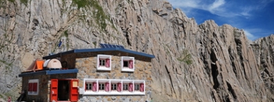
Located in the Cirque de Troumouse, the old Cabane des Aires (Aires Hut) was used every summer until the early 20th century by the shepherds and their flocks. Neglected, it was rehabilitated in 2005. This architectural ensemble reflects the pastoral history of the territory. Far from predators, it provided a secure spot for the flocks and shepherds to rest. Generally, several shepherds occupied the hut simultaneously. Early each summer, the shepherds repaired the hut to make it habitable after the storms of the winter season, and would stay there until September. Every night they brought the animals to the coueyla (mountain shelter for men and animals) to milk them in the pen set aside for the task.
Today only the enclosure is still used for pastoral reasons.
Establishment of communities
Man first inhabited these valleys around 40,000 to 10,000 BC, as evidenced by sites such as the caves of Aiisclo and Escuain, stone cirques at Gavarnie and the dolmen of Tella.
Though nomadic at first, the agro-pastoral communities eventually settled on both sides of the current border. They adapted to the extreme weather conditions and used the resources of the surrounding nature. They exploited the minerals and timber. They controlled water streams and cultivated their terraced fields on upland pastures, forever shaping the landscape. They wove a network of trails to promote trade between the valleys. For centuries the valleys of Mont Perdu served as a link and joined the two communities by developing a culture and an identity established on a specific legal and political system, independent of the central government.
From the 14th century onward, written agreements intended to ensure peace between the valleys governed pastoral customs and trade.
Pastoralism
For centuries, man has adapted to his environment and used what he needed to live or survive in the high mountains. He traveled along the roads and bridges, rested in refuges at the end of mountain passes (visible in Gavarnie, Bujarelo, Aragnouet, Parzan, Héas and Pinet), and sought shelter in the coueylas (mountain shelters) ...
The high, huge pastures like those of Gaulis (or Góriz) or Ossoue provide an invaluable testimony to the system of transhumance and the cultivation of these altitude areas. It is the continuity of this tradition of pastoral transhumance in the mountains that makes this an exceptional site, and an example for other mountain regions of Europe.
Transhumance of the Bernatoire
During the summer, the Ossoue mountain (located on the slopes of Gavarnie in France) is the property of the Broto Valley (in Spain). The shepherds of this valley still send more than 1,000 cows through the Col de la Bernatoire from late July to September. See "Walking and Hiking."
These exchanges are the living testimony of ancestral agreements dating back to the 13th century between the Spanish and French communities of Mont Perdu.
Natural Environment
Natural Landscapes
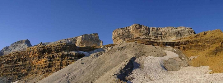
These landscapes include, to the south, three Spanish canyons among the largest and deepest in Europe (Anisclo, Pineta and Ordesa) and to the north, on the French side, the cirques of Gavarnie, Estaubé and Troumouse. The classified area, which is the most magnificent ensemble of Pyrenean scenery, is bordered on the north by the towns of Gavarnie and Gèdre.
The cirques
The Cirques de Gavarnie, Estaubé and Troumouse are majestic natural formations dating back to the Ice Age. Gavarnie is the best known, with its 1,500 meter wall and at its center, the largest waterfall in Europe (427 meters). Equally impressive is the Cirque de Troumouse, the largest. And finally, the Cirque d’Estaubé is the most untouched of the three. More than a dozen peaks dominate the three cirques, rising to over 3,000 meters.

Climates, plant and animal species
There are climatic differences between the northern and southern slopes : the French side is wet while Spanish slopes are drier. The climate also varies to the west (maritime) and to the east (Mediterranean). These climatic contrasts generate five types of vegetation in an extremely small area. This natural wealth gives the site its outstanding environmental value.
These natural environments contain an exceptionally rich mountain fauna and flora. The Pyrénées mountains are home 3,500 plant species, 5% of which are endemic (unique to the Pyrénées). In addition, the site is home to many species, such as the izard (a kind of mountain goat) and the groundhog, which was reintroduced to the area, or the Spanish ibex, which is now an endangered species.
The Pyrénées National Park
Established in 1967, the Parc National des Pyrénées (Pyrénées National Park) works toward the harmonious development of villages in the classified area, in the respect for nature and the mountains, but also the lives of those within the territory and their pastoral activity. The National Park protects its extremely rich and fragile fauna and flora from external pressures.
The Maison du Parc National
65120 Gavarnie
Website - tel : 05 62 92 42 48.
Opening time:
July and August, every day: 10 a.m. to 12:30 p.m./ 2:30 p.m. to 6:30 p.m.
Rest of the year, Tuesday to Saturday: 10 a.m. to 12:30 p.m. / 2:30 p.m. to 5:30 p.m.
Accommodation available for visitors with disabilities. Features informational films on the flora and fauna of the park. Permanent exhibition on the movement of Pyrénéisme (combines mountaineering and Pyrénées culture) and the cirques. Also features many documents and information that is strongly recommended before beginning to hike. Free access.
The Mountains for everyone
For several years, the National Park has been involved in a project for opening mountain access to all: motor, mental, visual and hearing handicaps, and those with social difficulties.
Ordesa y Monte Perdido National Park (Spanish side)
Plaza de Cervantes, 5
22071 Huesca (España)
Tel : +34 974 243 361.
Established in 1918, the area covered has since expanded (in 1982) to include the whole mountain range of Mont Perdu and the valleys of Ordesa, Anisclo, Escuain and of the Pineta. Its functions are similar to the Pyrénées National Park.
Tourist Office
Tourist Offices in the Gavarnie Valley
Tourist Office in Gavarnie
65120 Gavarnie
Website - tel : 05 62 92 49 10.
Opening time:
January through June, September and October, Monday to Saturday: 9 a.m. to 12 p.m. / 2 p.m. to 5 p.m., open on Sunday during public holidays.
July and August, every day: 9 a.m. to 7 p.m.
November and December, Monday to Friday: 9 a.m. to 12 p.m./ 2 p.m. to 5 p.m.
Tourist Office in Gèdre
Place de la bergère, 65120 Gèdre
65120 Gèdre
Website - tel : 05 62 92 48 05.
Opening time:
Monday to Saturday: 9 a.m. to 12 p.m. / 2 p.m. to 6 p.m., open on Sunday during public holidays.
July and August, daily: 9 a.m. to 12 p.m. / 2 p.m. to 6:30 p.m.
Accommodation available for visitors with disabilities.
Transport
Getting to Gavarnie and Gèdre
By Car
From Tarbes : highway N21 until Lourdes, then D821 until Argeles-Gazost, then D921 to Gèdre.
Nearby classified
sites
Toulouse (Canal du Midi) : 245 km (152 mi), time: 3 hours
Bordeaux : 291 km (181 mi), time: 3 hours, 40 minutes
By Plane
Tarbes, Lourdes, Pyrénées Airport
65290 Louey
Website - tel : 05 62 32 92 22.
To Gèdre by car: 53 km (33 mi), time 1 hour, 10 minutes
Pau Pyrénées Airport
64230 Uzein
Website - tel : 05 59 33 33 00.
To Gèdre by car: 91 km (56.5 mi), time: 1 hour, 45 minutes
By train
Gare SNCF Lourdes
33 Avenue de la Gare,
65100 Lourdes
Website - tel : 36 35.
To Gèdre by car: 45 km (29 mi). Time : 1 hour.
By bus
Maligne
Website - Tel: 05 62 56 72 73.
Line : "Ma ligne Tarbes-Lourdes-Luz-Gavarnie".
Warning: runs every day from June through September and from Decembre through March only. Lourdes to Gavarnie, time: 1 hour, 30 minutes.
Parking in Gavarnie
From May to October, parking in the village of Gavarnie is chargeable. Price: €5 per vehicle for a period of 24 hours.
Sleeping / Eating
Accommodation
These addresses are in the immediate vicinity of the site. The prices shown are for the off season, on the basis of 2 people.
Tipis Indiens
65120 Saussa
Website - tel : 06 15 41 33 29.
Tipi 4 persons, price from €115.
3 km in the south of Gèdre, turn right direction plateau de Saugué. Kitchen available.
Compostelle Hôtel **
Rue de l’Eglise, 65120 Gavarnie
Website - tel : 05 62 92 49 43.
Room from €53.
Hôtel Le Marboré **
At the entrance of the village, 65120 Gavarnie
Website - tel : 05 62 92 40 40.
Room from €100.
Restaurant : "menu" from €20.
Hôtel Vignemale ***
Chemin Du Cirque, 65120 Gavarnie
Website - Tél : 05 62 92 40 00.
Room from €160.
Restaurant in Gavarnie
The “menus” usually consist of a starter, a main course and a dessert," for lunch or dinner.
Restaurant Les Cascades - local cuisine
In the village center, 65120 Gavarnie
Website - Tel: 05 62 92 40 17.
"Lunch formule" €16. "Menu" from €23.90.